Pillar: Buying building land in France
Clay shrink-swell hazard in France: reading the exposure map and what it means for building
In mainland France, the “retrait-gonflement des argiles” map on Géorisques rates the parcel’s location as low, medium, high or residual exposure. In a medium or high zone, the seller of undeveloped building land owes you a preliminary geotechnical study, subject to a planning exception set out below, and the builder of the house follows a design study or applies the techniques set by ministerial order.
In brief
- In mainland France (the territoire hexagonal), the map drawn by the BRGM, the French geological survey, and published on the government hazard portal Géorisques shows three levels of clay exposure, low, medium or high, and rates the rest as residual exposure (no clay identified so far). The ELAN Act rules only apply in medium and high zones. Since the update that applies to sales and contracts signed from 1 July 2026, those two zones cover 55% of mainland France, against 48% in 2020.
- When undeveloped building land in a medium or high zone is sold, the seller must supply a preliminary geotechnical study, at their own cost, attached to the preliminary contract; it is valid for 30 years provided the ground has not been reworked (remaniement du sol). According to the ministry, the only exemption is for areas where the planning documents expressly ban detached houses.
- To build a house (two dwellings at most), you pass that study to the builder. The builder follows a design study for your project, if there is one, or applies the techniques set by ministerial order, including foundations at least 0.80 m deep in a medium zone and 1.20 m in a high zone, unless hard non-clay ground is reached first. A design study is not required in every case.
- Drought cracking is covered by the natural-disaster cover in the property’s insurance once the commune (the municipality) is recognised by an inter-ministerial order (arrêté); statutory excess for a private policyholder: €1,520 per claim.
On this page
Reading the exposure map
Clay soils shrink in dry spells and swell when the rain returns. The movement is slow but enough to crack a house, usually with diagonal cracks in the walls running through windows and doors. The typical damaged house is single-storey, on unsuitable foundations, with trees nearby.
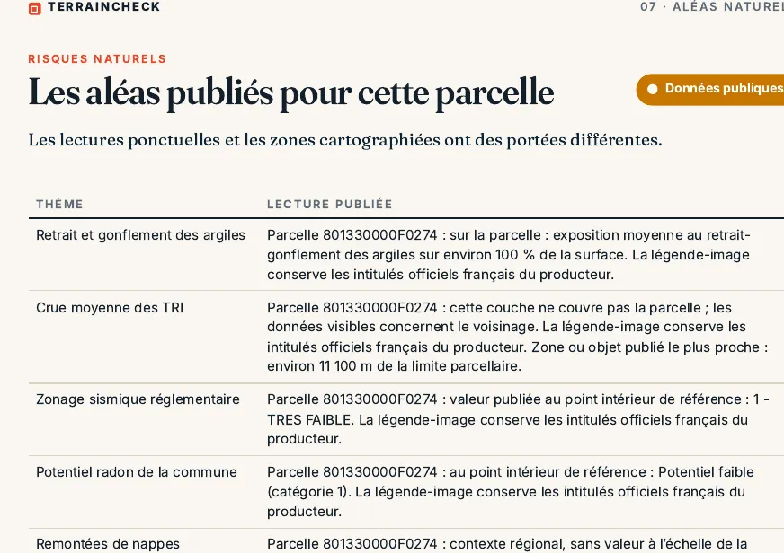
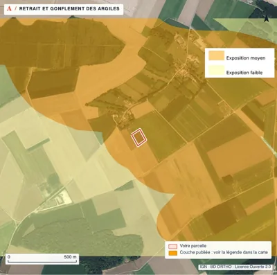
On the Géorisques interactive map, switch on the “retrait-gonflement des argiles” layer and zoom in on the parcel. In the address report the same hazard appears as a level out of 3: for a point next to parcel F 274, in a medium zone, it read “Modéré”, 2/3 (how to read that report).
| Exposure | What the map shows | When undeveloped buildable land is sold | To build a house |
|---|---|---|---|
| High (forte) | Mainly clay formations, thick and continuous, very sensitive material | Preliminary geotechnical study from the seller | Design study or the techniques in the order (foundations ≥ 1.20 m, unless hard non-clay ground is reached first) |
| Medium (moyenne) | Thin or patchy clay formations, moderately sensitive material | Preliminary geotechnical study from the seller | Design study or the techniques in the order (foundations ≥ 0.80 m, unless hard non-clay ground is reached first) |
| Low (faible) | Non-clay formations with local pockets of clay | No duty under the ELAN Act | No duty under the ELAN Act; a study is still a sensible choice |
| Residual (résiduelle) | Outside the three zones: no clay ground identified so far | As in a low zone | As in a low zone |
The four categories on the map (Construction and Housing Code, art. R132-3) and their effects under the ELAN Act, for houses of up to two dwellings. The preliminary study is not owed where the planning rules do not allow detached houses. Sources: Construction and Housing Code, art. R132-3 to R132-8; Construction and Housing Code, art. L132-5; Construction and Housing Code, art. L132-7. Accessed 12 November 2026.
The new zoning, set by the order of 9 January 2026, applies to sale contracts and deeds for undeveloped building land, and to house-building contracts, signed from 1 July 2026. A map printed before the update may show an outdated rating: 12.1 million detached houses are now in a medium or high zone, against 10.3 million on the 2020 map.
At the sale: the preliminary geotechnical study
Article L132-5 of the Construction and Housing Code, introduced by the 2018 ELAN Act, requires the seller of undeveloped buildable land in a medium or high exposure zone to supply a preliminary geotechnical study. It is attached to the preliminary contract, or failing that to the deed, and stays with the title: it passes on with every later sale.
- Who: the seller, at their expense, whoever the buyer is.
- What: a desk study, a site visit and, where needed, boreholes. A G1-type study meeting standard NF P 94-500 (November 2013) is presumed compliant.
- How long: 30 years, provided the ground has not been reworked (art. R132-6).
- Exemption: the duty only falls away where the planning documents expressly ban detached houses in the area. A ministerial answer published on 2 June 2026 confirms that a buyer saying they will not build is not enough.
To build: a design study or the techniques in the order
Before signing a building contract or a project-management contract for a house (two dwellings at most) in a medium or high zone, the client, meaning you, passes the preliminary geotechnical study received with the land to the builder (article L132-6 of the Construction and Housing Code). If that study is not attached to your title deed, you supply an equivalent preliminary study or a geotechnical design study, one that takes account of the building’s position and characteristics.
The builder then has two routes (article L132-7): follow the recommendations of a geotechnical design study, supplied by you or carried out by the builder with your agreement, or apply the specific building techniques set by the order of 22 July 2020. So the law does not make you order a design study in every case: without one, the builder applies the techniques in the order. If the geotechnical study finds no risk of differential ground movement, the builder is not bound by that duty. A design study is valid only for the project it was made for (art. R132-6).
If you sign a contrat de construction de maison individuelle (CCMI), the regulated French contract with a house builder, it must describe the ground-adaptation works, including any that the geotechnical study calls for, and a copy of the study is attached to it. Read that section with a translator before signing: it is where deeper foundations show up in the price.
The 2021 leaflet from the Bas-Rhin préfecture (the State’s office in that département) is stricter than the order: 1.5 times the height for all vegetation, and partial basements banned. The order in force uses once the adult height of a tree, one and a half times the height of a hedge, and evenly anchored foundations, including with a partial basement.
The cost of a study or of deeper foundations is set by quote. When a new detached house in a medium or high zone is finished, a certificate that the hazard was taken into account goes with the completion declaration (DAACT); a building inspector, an approved design office or the builder can issue it.
The steps before you buy
- Read the map. Géorisques, “retrait-gonflement des argiles” layer, at parcel scale. Free, a few minutes.
- Ask the seller for the preliminary study. In a medium or high zone, subject to the planning exception: paid by the seller, attached to the contract. Check its date and ask whether the ground has been reworked since.
- Have the conclusion read by the builder or project manager you have in mind: they will say whether the foundations change the budget. Ask for quotes.
- Pass the study to the builder and choose the route before the building contract: a design study (a G2 study under standard NF P 94-500, on a quote with a delivery date) or the techniques in the order of 22 July 2020.
- Check the commune’s history. Natural disaster orders (arrêtés) on Géorisques; ask the mairie about cracked houses nearby.
Cracks, insurance and the drought record
Drought damage is paid under the natural-disaster cover (garantie catastrophe naturelle, or CatNat) that is automatically part of French insurance policies covering damage to property, provided the commune is recognised by an inter-ministerial order (arrêté) published in the Journal officiel.
| Step | Who | Deadline or amount |
|---|---|---|
| Reporting the damage | You | As soon as you know of the damage, and at the latest 30 days after the order is published |
| Statutory excess for a private policyholder | Borne by you | €1,520 per claim for clay shrink-swell; €380 for other hazards, or your policy’s storm, hail and snow excess if that is lower |
| Advance | The insurer | 2 months from your estimate of the damage or from the order’s publication |
| Settlement | The insurer | 3 months from your estimate, or from the order’s publication if that comes later, barring unforeseeable events or force majeure |
CatNat cover for a private policyholder after a drought. Your policy may set more favourable terms. Sources: Géorisques: the Cat-Nat insurance scheme; Service-Public: natural disaster insurance claims. Accessed 12 November 2026.
Report the damage to the mairie as well: the mayor has 24 months after the event to apply for the commune’s recognition.
For a detached house, Géorisques puts the average cost of a clay-related claim at €16,500.
In our report: the clay hazard on the parcel
Before the preliminary contract: the clay checklist
- Parcel rating read on the map in force since 1 July 2026.
- Medium or high zone: preliminary study less than 30 years old attached to the contract, ground not reworked since.
- Study conclusion read with your future builder; foundation budget quoted.
- Trees and hedges near the house footprint noted (tree: once its adult height; hedge: one and a half times its height).
- The commune’s drought orders checked.
- Route agreed with the builder before the contract: a design study or the techniques in the order.
Read next: classified industrial sites around the plot and the order of checks before the compromis (the preliminary sale contract).
- Géorisques: how to read the hazard report for a French plot and what it leaves out
- Classified sites (ICPE) near a plot in France, farms included: where to find them and what they mean
- Buying building land in France: the PLU, the certificat d’urbanisme, boundaries and the soil study before the compromis
Keep reading
Géorisques: how to read the hazard report for a French plot and what it leaves out
Classified sites (ICPE) near a plot in France, farms included: where to find them and what they mean
Buying building land in France: the PLU, the certificat d’urbanisme, boundaries and the soil study before the compromis
How much of your parcel sits on clay
Select the parcel on the map: the report measures how much of its outline lies in each clay zone and also covers flooding, seismic zone, underground cavities and the planning document that applies, with the source and date of each item, explained in English. Free preview, PDF report for €29 (€39 in French and English).
