Pillar: Buying building land in France
Reading the PLU before you buy land in France: zone, rules, easements and pending changes
On this page
This guide shows how to read the local plan (plan local d’urbanisme, PLU) for a plot before you sign: find the right document and version, read the zone and its rules, spot what sits on top of the zoning and check that no change is under way.
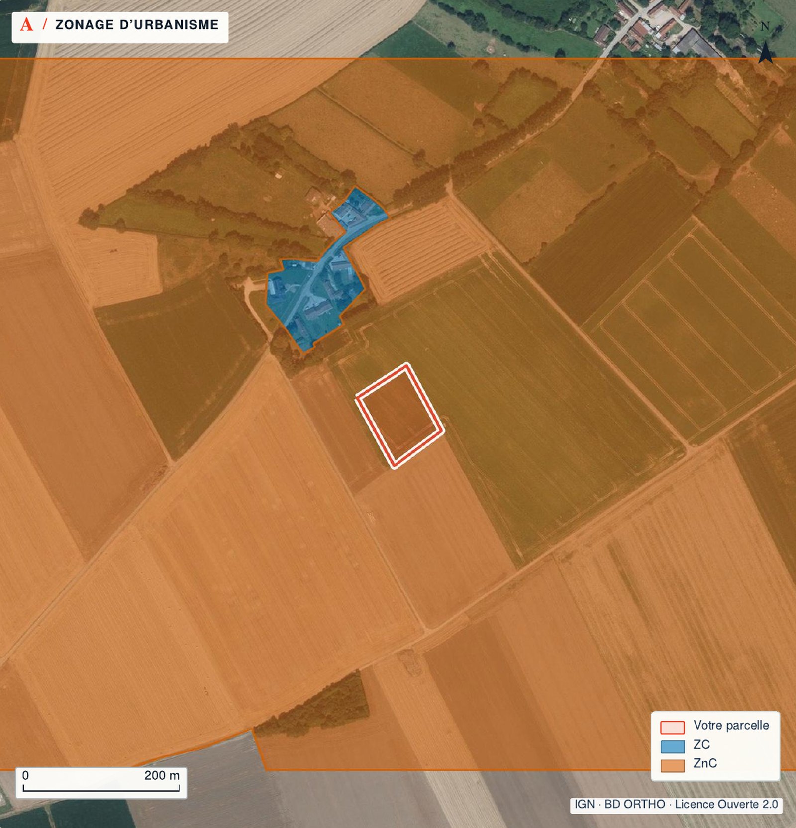
Have a parcel in mind? The report reads its PLU zone on the exact outline, with the plan’s date, the easements and the hazards: €29 in one language, €39 in French and English, by email within 45 minutes. Pick the parcel on the map →
What a PLU contains
A plan local d’urbanisme (PLU, local plan) is not a single map. It is a file of several parts, listed in the Planning Code (art. L151-2). They do not carry the same weight: some bind your project to the letter, others only in spirit.
| Part | What it contains | Weight for your project |
|---|---|---|
| Presentation report | The reasons for the choices and the environmental assessment. | It explains the rules; it is not among the binding parts. |
| PADD | The municipality’s planning strategy. | Does not bind third parties, but once far enough advanced it can justify a postponed permit decision. |
| OAP | Orientation plans for given sectors or themes. | Binding in spirit (“compatibility”, art. L152-1). |
| Written and graphic rules | The zoning map and the rules of each zone. | Binding to the letter (“conformity”). |
| Annexes | Including public-interest easements. | Easements bind like the rules. |
A PLUi also has a programme of orientations and actions. To find out what you may build, read the rules and the annexes first. Sources: Ministry of Ecological Transition: PLU guide, 2020 (art. R151-18, R151-22, L151-43); Géoportail de l’Urbanisme: the PLU and its parts. Accessed 29 October 2026.
PLU, PLUi, carte communale or RNU: which document applies
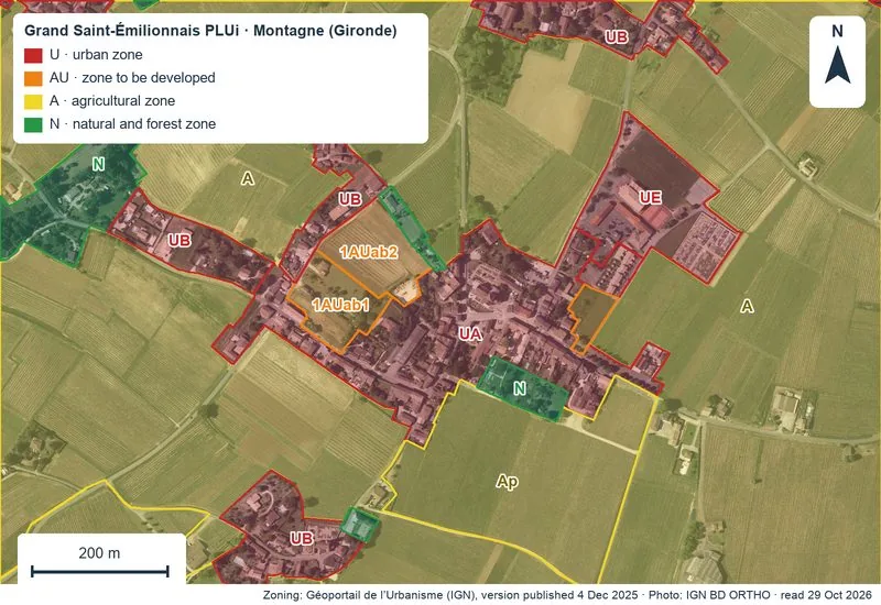
Before reading a rule, check which document covers the land. The map at the top of this page shows a PLUi, the Grand Saint-Émilionnais plan, applied to the village of Montagne: the municipality has no plan of its own, the group of municipalities holds it.
The four possible cases
- PLUA plan for one municipality, with zoning, written rules and annexes.
- PLUiThe same document for a group of municipalities, when it covers their whole territory.
- Carte communaleIt marks where building is possible but does not regulate siting on plots in detail: the national rules then apply to buildings.
- RNUWithout a planning document, the national planning rules apply (Planning Code, art. R111-1 to R111-27). No PLU does not mean no rules.
Reading the PLU on the Géoportail de l’Urbanisme
Every new version of a planning document approved since 1 January 2020 must be published on the Géoportail de l’Urbanisme. Since 1 January 2023, that publication, together with transmission to the prefect, is what makes a PLU enforceable (Planning Code, art. L153-23): at once where a SCoT covers the area, one month later otherwise.
The rule is not retroactive: a version in force before 2023 remains enforceable even if it is not online. Read the PLU on the portal, then have the town hall confirm the version that applies, with its date.
- Open the Géoportail de l’Urbanisme map and search for the address or the municipality.
- Click the parcel to see its zone and label (for example UB, 1AUab or Ap).
- Open “Plus d’informations” for the document: name, publication date, written parts.
- Read the rules of the zone, then the requirements and easements that touch the parcel.
- Check the “Procédures en cours” tab: councils publish there the start and approval of changes to the PLU.
Sources: Géoportail de l’Urbanisme: FAQ (Planning Code, art. L153-23); Ministry of Ecological Transition: the Géoportail de l’Urbanisme explained; Géoportail de l’Urbanisme: tracking procedures (Planning Code, art. R153-20 and R153-22). Accessed 29 October 2026.
Reading the zone: U, AU, A, N and their suffixes
The first letter of the label gives the zone’s family. The figures and letters that follow (1AUab, Ap, UX) name sectors specific to each plan: their meaning is in that plan’s rules, not in a national code.
The four families of zones
- U · urban zoneAreas already built up, or where existing or planned public networks have enough capacity for new buildings (art. R151-18).
- AU · zone to be developedAreas meant to be opened to development. The rules and the OAP say when and on what conditions (art. R151-20).
- A · agricultural zoneAreas, serviced or not, protected for the farming, biological or economic potential of the land (art. R151-22).
- N · natural and forest zoneAreas, serviced or not, protected in particular for the quality of sites and landscapes or for forestry (art. R151-24).
The written rules: what decides your house
The rules can differ by zone and by 5 “destinations” and 21 “sub-destinations” of buildings (art. R151-27 and R151-28). The ministry recommends a three-part layout; that is where the answer to “can I build my house here, and how?” is found.
| Part | What it regulates | The question to ask |
|---|---|---|
| I. Use of land | Buildings and activities banned, or allowed on conditions, in the zone. | Is a dwelling allowed, and on what conditions? |
| II. Volume and siting (art. R151-39 and R151-40) | Height, footprint, setback from the road and the boundaries. | Does the house fit on the plot with the required setbacks? |
| II. Architectural and landscape quality (art. R151-41 to R151-43) | External appearance, fences, open space and planting. | Are the style, materials and garden share compatible with the project? |
| II. Parking (art. R151-44 to R151-46) | The number of spaces to provide. | Where will the required spaces go? |
| III. Roads and networks (art. R151-47 to R151-50) | Access by a road and connection to networks. | Does the plot have adequate access and networks? |
An older PLU may still be laid out in numbered articles. Sources: Ministry of Ecological Transition: PLU guide, 2020 (art. R151-18, R151-22, L151-43); Ministry of Ecological Transition: drawing up a PLU or PLUi. Accessed 29 October 2026.
OAP, reserved sites, classified woodland
The zoning map carries other lines besides the zones. Three of them often change a project on building land.
Three lines to look for on the parcel
- OAPOrientations for a sector or a theme. A project must be compatible with them, with some room for judgement (art. L152-1).
- Reserved site (emplacement réservé)Land the public body plans to buy for a future public-interest use; it may not be put to a use incompatible with that purpose (art. L151-41).
- Classified woodland (EBC)Protected woods, hedges or trees: any change of use that would harm them is banned (art. L113-1 and L113-2).
Easements and hazards on top of the zoning
Public-interest easements are annexed to the PLU (Planning Code, art. L151-43) and bind like the rules. A U zone can therefore sit within the surroundings of a historic monument or under a risk prevention plan.
Two common easements
- AC1 · surroundings of a historic monumentWithout a defined perimeter, protection covers buildings within sight of the monument and less than 500 m from it. Works there need consent from the Architecte des Bâtiments de France.
- Risk prevention plan (PPR)An approved PPR is a public-interest easement annexed to the PLU (Environment Code, art. L562-4). It can ban building or impose requirements.
Zones A and N: what is still possible
In zone A, buildings other than agricultural ones are in principle not allowed (art. R151-23). The Planning Code provides a few exceptions, which the zone rules may or may not take up: read them for each parcel.
The exceptions in the code
- Farm buildings and public facilitiesBuildings needed for farming and for public facilities.
- An existing houseExisting dwellings may get extensions or outbuildings if they do not harm farming or the landscape; the rules set where, how high, how large and how dense (art. L151-12).
- Change of useA change of use of existing buildings, on the conditions of article L151-11.
- STECALExceptionally, the PLU may draw small sectors where other buildings are allowed (art. L151-13).
A changing PLU: modification, revision, postponed decisions
The act of 26 November 2025 simplified the procedures. Modification becomes the standard route and full revision is kept for the most structural changes; ordinary and simplified modification are merged into one procedure. The authority may choose an online public consultation instead of a public inquiry.
A change under way can affect your plot before it is approved. The mayor may postpone a decision on a permit for up to 2 years (sursis à statuer) if the project could compromise or make more costly the future PLU. A sufficiently advanced PADD is enough to justify it.
| Question | What the texts say |
|---|---|
| Where to see a pending procedure | In the document’s “Procédures en cours” tab on the Géoportail de l’Urbanisme, and at the town hall. |
| Does the planning certificate protect you? | It freezes the rules for 18 months, but states, where relevant, the circumstances that could justify a postponement. |
| After the postponement | You have 2 months to confirm your application; the mayor answers within 2 months, and silence means approval. |
| Blocked land | The owner may ask the authority to buy the land; it has 1 year to decide. |
When a public inquiry is still compulsory could not be checked at an official source; ask the town hall which consultation is planned. Sources: Ministry of Ecological Transition: planning simplification act of 26 November 2025; Ministry of Ecological Transition: leaflet on the act of 26 November 2025; Géoportail de l’Urbanisme: tracking procedures (Planning Code, art. R153-20 and R153-22); Service-public.fr: building permit (Planning Code, art. L421-1 ff.); Service-public.fr: certificat d’urbanisme (Planning Code, art. L410-1). Accessed 29 October 2026.
The certificat d’urbanisme: freezing the rules before you sign
The certificat d’urbanisme is free and a prospective buyer may apply. The information certificate gives the rules, easements and taxes; the opérationnel one also says whether the plot can take the project described. The town hall has 1 month for the first and 2 months for the second. For 18 months, a permit application is judged under the rules in force on the certificate’s date (Planning Code, art. L410-1).
For building land, apply for the certificat opérationnel with a simple description of the house. The guide French planning certificates explains the application. See also flood risk checks.
Sources: Service-public.fr: certificat d’urbanisme (Planning Code, art. L410-1). Accessed 29 October 2026.
From the PLU to the building permit
| Step | Rule | Worth knowing |
|---|---|---|
| Which permission | A building permit for any building over 20 m², including a detached house; a prior declaration for smaller works. | Above 150 m² of floor area, the plans must be drawn by an architect. |
| Time to decide | 2 months for a detached house from the date the file is complete; 3 months for other projects. | The file and the periods differ in a protected area. |
| A neighbour’s appeal | 2 months to go to the administrative court from the first day the permit is posted on site; 1 month for an appeal to the mayor or prefect. | An appeal to the mayor no longer extends the 2 months. If the permit is never posted, the period is 6 months after the works are finished. |
Since 28 November 2025, procedural defects of a PLU can no longer be raised indirectly against a permit; substantive defects still can. Sources: Service-public.fr: building permit (Planning Code, art. L421-1 ff.); Service-public.fr: challenging a neighbour’s planning permission; Ministry of Ecological Transition: sheet 4, appeal periods against permits, May 2026; Ministry of Ecological Transition: sheet 2, challenging planning documents, May 2026. Accessed 29 October 2026.
When to hold back your signature
Four levels before you pay anything
- StopZone A or N without a STECAL, or a reserved site or EBC on the footprint of the house.
- PauseAn AU zone whose opening is not settled, a change of the plan under way, a PLU version not confirmed by the town hall.
- ConditionThe project depends on the permit: write a condition precedent for a permit free of appeal, with dates.
- Go onZone U, rules compatible with your house, no blocking easement, a recent certificat opérationnel for your project.
Three hypothetical examples
These cases are invented to show the method. They do not describe any real parcel.
Hypothetical example
A UB zone on a narrow plot
The parcel is in zone UB but narrow. The rules require a setback from the road and from the side boundaries. The buyer has the possible footprint of the house drawn on the cadastral plan, applies for a certificat opérationnel and signs with a building-permit condition.
Hypothetical example
A 1AU sector under an OAP
The land is in 1AU and an OAP plans an access road across the back of the plot. The project must stay compatible with it. The buyer asks the town hall when the road is due and scales the project down to the free part.
Hypothetical example
An announced revision
The seller says the land will become buildable. On the Géoportail, the “Procédures en cours” tab shows a procedure started but not approved. The buyer sticks to the PLU in force and negotiates the price of non-buildable land.
The steps before the compromis
- Find which document applies: PLU, PLUi, carte communale or RNU.
- Read the parcel’s zone and the document’s publication date on the Géoportail.
- Read the zone rules, part by part.
- Look on the map for OAP, reserved sites, EBC and requirements that touch the parcel.
- Read the list of public-interest easements in the annex.
- Check the “Procédures en cours” tab and ask the town hall whether a change is planned.
- Apply for a certificat opérationnel for your house.
- Have a building-permit condition with dates written into the compromis.
Questions for the town hall and the seller
- Which planning document applies to the parcel, and what is the date of the version in force?
- Which zone is it in, and what do the rules say about a dwelling?
- Does an OAP, a reserved site or a classified woodland touch the parcel?
- Which public-interest easements apply to it?
- Is a modification or revision of the PLU under way or planned?
- Has a certificat d’urbanisme already been issued for this land, and for what project?
- Are the road and networks in front of the plot enough for a house?
- Has a permit ever been refused or withdrawn on this parcel?
Common questions
Where can I read a municipality’s PLU?
On the Géoportail de l’Urbanisme, where every version approved since 2020 must be published, and at the town hall, or at the head office of the group of municipalities if it holds the plan. Have the version in force and its date confirmed.
Does a U zone guarantee I can build?
No. The zone sets the frame; the rules fix height, setbacks, footprint and access, and easements can add limits. A certificat d’urbanisme opérationnel answers for your project.
What does a label such as 1AUab or Ap mean?
The first part gives the zone family (AU, A). The rest names a sector specific to the plan: its meaning is given by that PLU’s rules.
Can I build a house in zone A or N?
In principle no, except where the code allows it and the rules take it up: an extension or outbuilding to an existing house, a change of use of a named building, or a STECAL drawn by the PLU.
How do I know whether the PLU will change?
Check the document’s “Procédures en cours” tab on the Géoportail de l’Urbanisme, where councils publish the start and approval of procedures, and ask the town hall.
What is a sursis à statuer?
A postponement of a permit decision, up to 2 years, when the project could compromise the future PLU. The planning certificate states, where relevant, the circumstances that could justify it.
Can my permit be challenged?
Yes, for 2 months before the administrative court from the first day it is posted on site. If it is never posted, the period runs until 6 months after the works are finished.
What does the TerrainCheck report show about the PLU?
The zone read on the parcel’s exact outline, the share of each zone, the date of the published plan and the heritage easements, on a map with its source. It does not replace the written rules or the certificat d’urbanisme.
Keep reading
Buying building land in France: checks before the compromis
Is a plot buildable in France? How to check the zone, utilities, easements and the official answer
Easements (servitudes) on French land: where to find them before you buy
Searching for a parcel on cadastre.gouv.fr and Géoportail (now cartes.gouv.fr): what each tool does
French cadastral reference: how to find a parcel number and read it correctly
How to find who owns a plot of land in France, lawfully
Read the zone of your parcel
Pick the parcel on the map: PLU zone, easements, hazards, Natura 2000 and heritage are read for it, with source and date. Free check, PDF report for €29 (€39 in French and English).
