Pillar: Buying building land in France
Searching for a parcel on cadastre.gouv.fr and Géoportail (now cartes.gouv.fr): what each tool does
On cadastre.gouv.fr you search within a commune, by address or by prefix, section and number, and print an A4 or A3 extract free of charge. Géoportail is now cartes.gouv.fr, handy for clicking on a parcel and measuring it.
In brief
- On cadastre.gouv.fr, enter the commune (the French municipality) by name or postcode, then the address or the reference: prefix, section, number. An A4 or A3 map extract prints free of charge.
- Géoportail has been replaced by cartes.gouv.fr (“Explorer les cartes”); geoportail.gouv.fr now redirects there. You can pick a parcel on the map, measure it and export the map as a PDF.
- For the parcel’s planning zone, the Géoportail de l’Urbanisme, the national portal for local planning documents, has a “search by parcel” button; its documents are for information only.
- None of these tools gives the owner’s name or the legal boundary: the French cadastral map is a tax document.
On this page
Which tool answers which question
Four public websites show French cadastral parcels, each for a different job. The table sums up what each one does; viewing is free on all four.
| Tool | Search by | What you get | Cost | Good to know |
|---|---|---|---|---|
| cadastre.gouv.fr (tax office, DGFiP) | Address, or prefix + section + number, within a commune | The current map, a printable extract, a location plan you can annotate | A4/A3 extract free; full A0 sheet €9.50 (paper) or €18 (plastic) | Kept up to date continuously by the DGFiP; no search by name |
| cartes.gouv.fr, formerly Géoportail (IGN, the national mapping agency) | Click on the map, a circle or a rectangle: “Parcelles cadastrales” | Parcel on aerial photo, distance and area measuring, PDF export | Free | 20 results at most within a circle or rectangle; measurements are made on a drawing |
| Géoportail de l’Urbanisme | “Search by parcel”, or by address | Zoning and rules of the local planning document: a PLU (plan local d’urbanisme, the local plan), a carte communale (a map of the sectors where building is and is not allowed, with exceptions) or another; published public-interest easements | Free, no account | For information only; the binding version is the one held by the competent local authority |
| cadastre.data.gouv.fr (Etalab) | Map and downloads per commune | Parcel outlines and recorded area, open files | Free | Refreshed about every 3 months; map data only, no owners |
The four public portals, consulted on 12 November 2026. Sources: impots.gouv.fr: access to cadastral records; collectivites-locales.gouv.fr: how the cadastral map is published; Service-Public: how to consult the cadastre; cartes.gouv.fr: finding an address or a parcel; Géoportail de l’Urbanisme: public user manual (v4.5); cadastre.data.gouv.fr: open cadastral data; data.gouv.fr: working with cadastral data. Accessed 12 November 2026.
On cadastre.gouv.fr, step by step
- Open cadastre.gouv.fr and enter the commune, by name or postcode. Cost: nothing, no account. Time: a minute.
- Search by address or by reference. For a reference the site needs three items: the prefix, pre-filled as 000, the section and the number. Where communes have merged, the “Liste des préfixes” link shows the former communes’ prefixes. How to read a reference is covered in our guide to the cadastral reference.
- Check the parcel shown. Compare its shape, tracks and buildings with what you saw on site or on an aerial photo. A field with no landmarks is easily mistaken for the one next to it.
- Print the extract. A4 or A3 extracts are free; the advanced tools set the orientation and scale. A location plan in the same sizes can be annotated. Full A0 sheets are charged for and ordered online through a customer account.
The site covers 598,788 map sheets. The tax office updates it continuously, while Etalab’s open files are refreshed about every three months, so a recent division may show on cadastre.gouv.fr before it reaches the open files.
Géoportail, now cartes.gouv.fr
IGN presents the “Explorer les cartes” service at cartes.gouv.fr as the successor to Géoportail, and geoportail.gouv.fr redirects to it. Old Géoportail links can be converted with the site’s permalink converter.
- Find the parcel: the “Trouver une adresse” tool, then “Parcelles cadastrales”. Point at a spot to get the nearest parcel, or draw a circle or a rectangle to get up to 20; each result can be copied.
- Measure: the “Mesurer une surface” tool. Each click adds a corner, the area updates as you draw, and a double-click finishes the shape. Switching tools wipes the drawing, so note the figure first.
- Export: the “Accéder à d’autres outils” button at the top left, then “Imprimer une carte”. Choose the format, layout, a title and the scale, and download a PDF. Cost: nothing.
The measurement is taken on the drawn outline, not on the ground. For why the two figures differ, see cadastral area vs real area.
Sources: cartes.gouv.fr: FAQ (Géoportail); cartes.gouv.fr: finding an address or a parcel; cartes.gouv.fr: measuring tools; cartes.gouv.fr: printing a map. Accessed 12 November 2026.
Adding zoning and hazards
The reference then works on other portals. On the “Cartographie” page of the Géoportail de l’Urbanisme, the search bar switches from place search to “search by parcel”. The parcel sheet then lists the rules that apply: zones, prescriptions and areas from the local planning document (PLU, carte communale and others), and public-interest easements. Its manual states that these documents are for information and that the binding version is the one held by the competent local authority. Reading the zone is covered in reading the PLU before buying.
For hazards, the Géorisques home page accepts an address or a cadastral parcel; see checking flood risk. On cartes.gouv.fr, the catalogue offers about twenty reference maps and, under “Toutes les cartes”, data by theme or producer, which you can add to the same map.
Sources: Géoportail de l’Urbanisme: public user manual (v4.5); Géorisques: hazards near me; cartes.gouv.fr: FAQ (Géoportail). Accessed 12 November 2026.
What the map shows, and what it does not prove
The data.gouv.fr cadastre guide is blunt: parcel outlines are an imprecise drawing, made before aerial photography became common, and only deeds of sale have legal force. Along commune borders, parcels may overlap or leave gaps.
A layer called “Décalage de la représentation cadastrale” helps judge the offset; it covers much of France, but not all of it. Then there is freshness: cadastre.gouv.fr is updated continuously, the open files about every three months. The dataset’s log shows gaps of about two months to just over five months between releases.
Sources: data.gouv.fr: cadastre FAQ; Service-Public: how to consult the cadastre. Accessed 12 November 2026.
In the report: the parcel plan
When to go to the town hall or a surveyor
The cadastral map can also be consulted at the mairie (town hall), searching by address or cadastral reference; the answer comes by post or, if you ask, electronically. Full-size sheets are ordered on cadastre.gouv.fr.
As soon as the boundary matters (a fence, buying part of a parcel, building near the edge), an online tool is not enough: the boundary is fixed by a bornage carried out by a géomètre-expert; see boundary surveys (bornage).
Sources: Service-Public: how to consult the cadastre. Accessed 12 November 2026.
Before you rely on the parcel you found
- Commune, prefix, section and number noted, with the date of the search.
- Parcel shape compared with the land (tracks, hedges, buildings).
- A4 or A3 extract printed from cadastre.gouv.fr, rather than a screenshot from a third-party site.
- Planning zone checked on the Géoportail de l’Urbanisme, then confirmed at the mairie.
- Any online measurement treated as indicative; boundary fixed by a géomètre-expert if it matters.
Read next: the order of checks before the compromis, the preliminary sale contract.
Keep reading
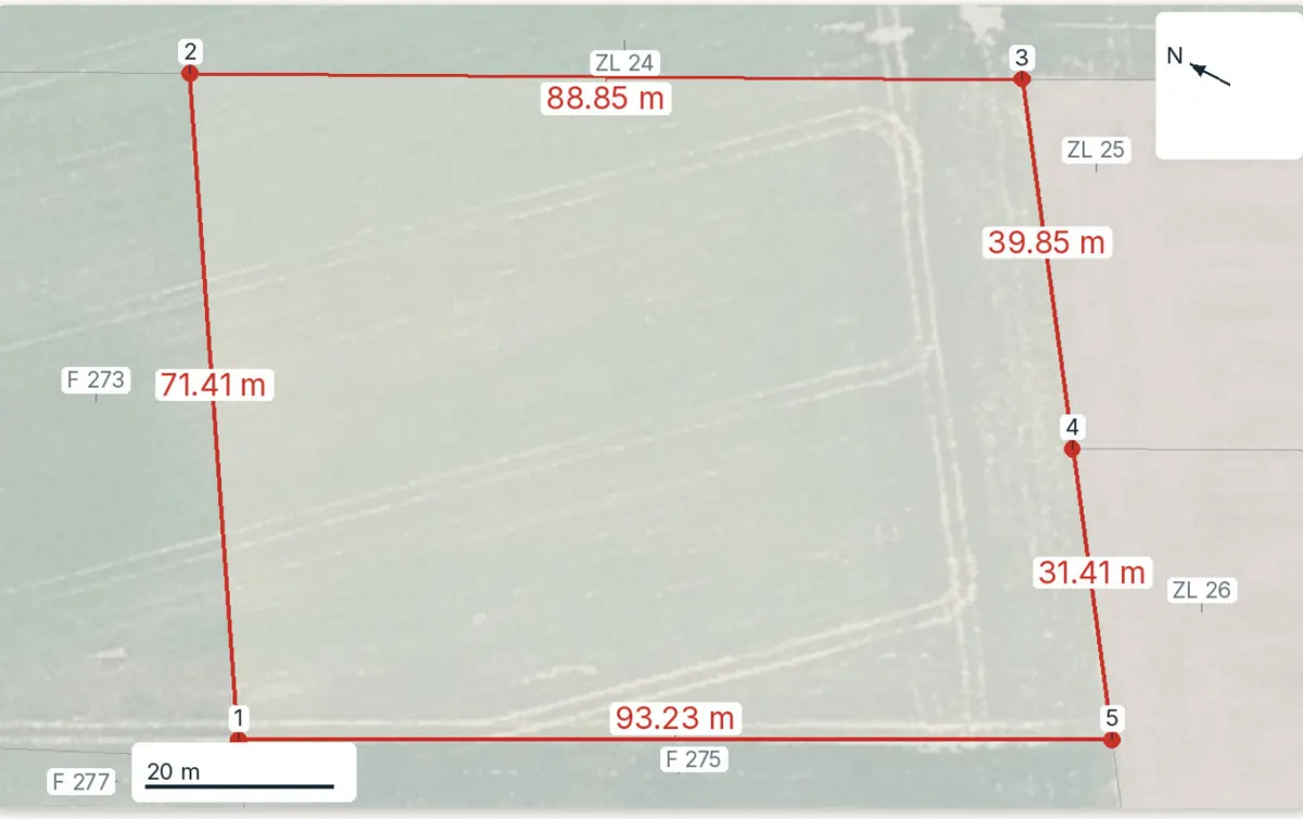
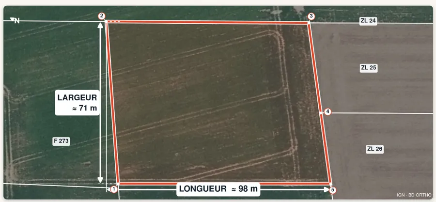
The parcel you found, checked in full
Pick the parcel on the map: the report gives its plan with side lengths, its planning zone, the hazards and recent land sales nearby, each with its source and date, in English. Free preview, PDF report for €29 (€39 in French and English).
