Pillar: Buying building land in France
Land in or near a Natura 2000 site in France: what changes for your project
On this page
This guide explains what a Natura 2000 site on or near building land means: where the boundary runs, when an impact assessment is required and who does it, what the charter and contract change, and which rules apply outside the site.
Have a parcel in mind? The report finds the nearest Natura 2000 site and gives the distance to its boundary, with the PLU zone and the hazards: €29 in one language, €39 in French and English, by email within 45 minutes. Pick the parcel on the map →
Natura 2000 in brief
Natura 2000 is an EU-wide network of land and sea sites. It aims at the long-term survival of threatened species and habitats and rests on two directives: the Birds Directive (2009/147/EC), whose sites are Special Protection Areas (ZPS), and the Habitats Directive (92/43/EEC), whose sites are Special Areas of Conservation (ZSC).
The ministry says it plainly: development projects and human activities are not excluded from the sites, provided they are compatible with the conservation goals.
| Natura 2000 in France | Figure |
|---|---|
| Sites | 1,756, including 403 ZPS and 1,353 ZSC |
| Share of mainland France’s land area | 13%, or 7 million hectares |
| Municipalities with a site | 13,041 |
| Share of urban areas within the sites | 1% |
Figures from the ministry page updated on 16 October 2025, which cites data from December 2021 and February 2022. Sources: Ministry of Ecological Transition: the Natura 2000 network (Environment Code, art. L414-1 to L414-7), updated 16 October 2025. Accessed 29 October 2026.
Inside the site, or next to it: reading the map
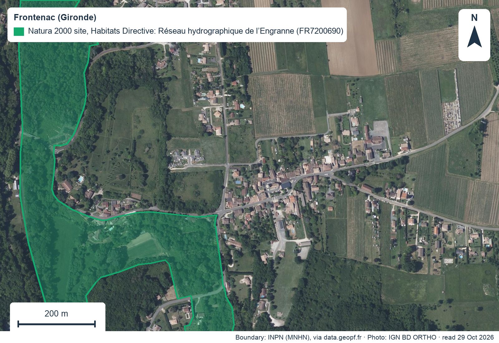
The map at the top of this page shows the village of Frontenac in Gironde and the site “Réseau hydrographique de l’Engranne” (FR7200690), designated under the Habitats Directive. The boundary follows the valley west and south of the houses: some plots are inside, others a few dozen metres away.
Each site has a nine-character code: FR, two digits for the region, then 0 for a Habitats Directive site or 1 for a ZPS, and a number. The official boundaries are those of the national INPN database, where each site has its own page and a standard data form listing its habitats and species.
Three situations to tell apart
- The parcel is inside the siteThe project may need an impact assessment, depending on the département’s lists. Read the management plan (DOCOB) at the town hall.
- The parcel touches the site or is closeThe national list also applies outside sites unless stated otherwise. Check the distance to the boundary and the kind of works.
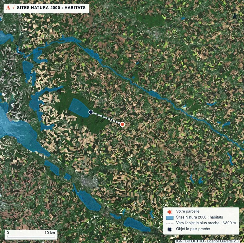
- The site is far awayOnly activities on lists that also apply outside sites need an assessment. Protected species remain protected everywhere.
What a Natura 2000 site changes, and what it does not
A Natura 2000 site does not make land unbuildable. What decides a house is still the planning document: the zone, the rules, the easements. Natura 2000 adds a question about the project’s effects on the site.
France chose to manage its sites through “voluntary contracts”, alongside the impact-assessment rules. Natura 2000 is not in the Géoportail de l’Urbanisme’s table of public-interest easement categories: do not look for it among the PLU’s easements, look at a map of the site.
Planning documents themselves face a stricter rule: drawing up a carte communale always needs an environmental assessment when the area includes all or part of a Natura 2000 site.
Sources: Ministry of Ecological Transition: the Natura 2000 network (Environment Code, art. L414-1 to L414-7), updated 16 October 2025; Géoportail de l’Urbanisme: table of public-interest easement categories, updated 20 October 2025; Ministry of Ecological Transition: the carte communale. Accessed 29 October 2026.
When an impact assessment is required
Plans, projects and events likely to affect a site significantly, alone or together with others, must go through an assessment of their effects (Environment Code, art. L414-4). Lists decide which projects are concerned.
| List | Who sets it | What it covers |
|---|---|---|
| National list (art. R414-19) | The Environment Code, 29 items. | For example projects needing an environmental impact study or environmental authorisation, water-law projects, planning documents. Unless stated otherwise, it applies inside or outside a site. |
| Local list 1 | The département prefect. | Activities that already need a permit or declaration, on top of the national list; it includes, for example, development permits (permis d’aménager). |
| Local list 2 | The prefect, from a reference list (art. R414-27). | Activities that needed no formality until now and come under a Natura 2000 authorisation of their own. |
| Catch-all clause (art. L414-4, IV bis) | The administrative authority, usually the prefect. | Exceptionally, a project on no list can still be made subject to assessment if it may harm the site. |
No official source read puts a house building permit on the national list. For your project, read local list 1 for your département, published by the prefecture. Sources: Ministry of Sport: text of article L414-4 of the Environment Code; DREAL Normandie: Natura 2000 impact assessments (Environment Code, art. R414-19); DRIEAT Île-de-France: which activities need an impact assessment; DREAL Grand Est: rules on Natura 2000 impact assessments. Accessed 29 October 2026.
The assessment: who does it, and what happens next
The impact assessment is the developer’s responsibility and is paid for entirely by them. They do not have to hire consultants. The study is proportionate: for a small project with negligible effects, a simplified assessment form is enough, and prefectures publish templates.
When the project already needs a permit or a declaration, the assessment file goes with that application. If significant harm to the site remains, the authority must oppose the project, except for a project of overriding public interest on strict conditions: only projects without significant impact can be approved.
Sources: Ministry of Ecological Transition: the Natura 2000 network (Environment Code, art. L414-1 to L414-7), updated 16 October 2025; DREAL Normandie: Natura 2000 impact assessments (Environment Code, art. R414-19); Natura 2000: booklet on impact assessment (Environment Code, art. L414-4). Accessed 29 October 2026.
Who runs the site, and whom to ask
The people behind a site
- COPILEach site has a steering committee that draws up the management plan.
- DOCOBThe management plan describes the site’s condition, goals and measures. It is not put to public inquiry and can be consulted at the town halls of the site.
- Local authority or operatorA local authority on the COPIL runs the plan, directly or through an operator; failing that, the State does.
- Site officer (animateur)Puts the plan into practice: charters, contracts, information for owners.
Charter, contract and land tax
The owner of land inside a site may sign up, if they wish. Work done under a contract, or in line with a charter’s activity-specific commitments, needs no impact assessment, but still needs the other formalities, such as a permit.
| Question | Natura 2000 charter | Natura 2000 contract |
|---|---|---|
| Length | 5 years | 5 years |
| In return | No payment | Funding |
| Land tax on undeveloped land | Exemption for the good-practice commitments only | Exemption (Tax Code, art. 1395 E) |
The exemption lasts 5 years. The plot must be on a prefect’s list drawn up after the DOCOB is approved; it covers farmland, meadows, orchards, woods, heath and ponds. A new buyer keeps it until the planned end if they sign a management commitment of their own. Sources: Ministry of Ecological Transition: the Natura 2000 network (Environment Code, art. L414-1 to L414-7), updated 16 October 2025; BOFiP: land-tax exemption for land in a Natura 2000 site (Tax Code, art. 1395 E), version of 19 July 2017. Accessed 29 October 2026.
On building land, the exemption covers only the undeveloped part. Ask the seller whether a charter or contract is running, and until when.
Protected species: a separate rule, everywhere
Outside any Natura 2000 site, listed species of fauna and flora are strictly protected (Environment Code, art. L411-1 and L411-2). It is forbidden, among other things, to kill or capture protected animals, to pick protected plants, and to destroy or degrade their habitat.
A derogation is possible on two conditions: there is no other satisfactory solution, and it does not harm the populations’ favourable conservation status; the project must also fit one of 5 legal grounds. Breaches are a criminal offence, punishable by a €150,000 fine and 3 years in prison since 4 February 2023.
Sources: DREAL Bretagne: rules on protected species (Environment Code, art. L411-1 and L411-2). Accessed 29 October 2026.
When to hold back your signature
Four levels before you pay anything
- StopThe PLU zone does not allow your house: Natura 2000 will not change that.
- PauseThe parcel is inside or touches the site and you do not know whether your project is on a list: ask the DDT before signing.
- ConditionAn assessment is required: put a building-permit condition in the compromis, with dates that leave time for the file.
- Go onThe site is far away, or the project is on no list, and the PLU zone allows your house.
Three hypothetical examples
These cases are invented to show the method. They do not describe any real parcel.
Hypothetical example
A garden at the edge of a valley
The parcel is in zone UB and its lower end lies inside a Natura 2000 site. The buyer asks the DDT whether a house on the upper part is on local list 1, sites the house outside the boundary and keeps the lower end as garden.
Hypothetical example
A plot 2 km from a site
The listing mentions a Natura 2000 site “nearby”. The map shows 2 km between the parcel and the boundary. The project is a house with no discharge into the stream; the DDT confirms that no list covers it. The buyer carries on with the usual PLU checks.
Hypothetical example
Woodland under a Natura 2000 contract
The land for sale includes a wood inside a site, under a Natura 2000 contract for two years. The notaire gives the contract’s end date. The buyer decides to sign a commitment of their own to keep the land-tax exemption until it ends.
The steps before the compromis
- Place the parcel against the nearest site: inside, on the edge or at a distance.
- Note the site’s name and code (FR followed by seven digits) and read its INPN page.
- Read the PLU zone and rules: they decide whether the house is allowed.
- Find local list 1 for the département on the prefecture’s website.
- Ask the DDT or the site officer whether your project needs an impact assessment.
- If it does, price the file and its timing, and build them into the compromis dates.
- Ask the seller whether a Natura 2000 charter or contract is running on the land.
- Have a building-permit condition with realistic dates written in.
Questions to ask before signing
- Is the parcel inside a Natura 2000 site, and which one (name and code)?
- If it is outside, how far is it from the boundary?
- Is my project on the national list or on a local list for the département?
- Who runs the site, and does the DOCOB plan measures on these parcels?
- Is a Natura 2000 charter or contract running, and until when?
- Have protected species been reported on the land or next to it?
- Has an impact assessment already been made for a project on this land?
Common questions
Can I build inside a Natura 2000 site?
The site does not make the land unbuildable: the PLU decides whether a house is allowed. Projects are not excluded from sites if they are compatible with the conservation goals, and some need an impact assessment.
Does my building permit need an impact assessment?
It depends on the lists: the national list in the Environment Code and local list 1 set by your département’s prefect. No official source read puts a detached house on the national list; check the local list.
Who pays for the impact assessment?
The developer, entirely. They do not have to hire consultants, and a simplified form is enough for a small project with negligible effects.
How do I know whether my parcel is inside a site?
Compare the parcel outline with the official INPN boundary on a map. Note the site’s name and code; the INPN page and the DOCOB at the town hall describe its habitats and species.
Is Natura 2000 shown in the PLU?
It is not in the Géoportail de l’Urbanisme’s table of public-interest easement categories. Look at a map of the site rather than the list of easements.
Does the Natura 2000 charter bring a tax advantage?
Yes, a 5-year exemption from land tax on undeveloped land for the good-practice commitments, if the plot is on the prefect’s list. A Natura 2000 contract also gives the right to it.
Does a site 2 km away change anything?
Only if the project is on a list that also applies outside sites, as the national list does unless stated otherwise. Protected species remain protected everywhere.
What does the TerrainCheck report show about Natura 2000?
The nearest site, its directive and the distance to the parcel boundary, or the overlap, on a map with its source. It does not say whether your project needs an assessment: the DDT answers that.
Keep reading
Buying building land in France: checks before the compromis
Reading the PLU before you buy: zone, rules, easements and pending changes
Géorisques: how to read the hazard report for a French plot and what it leaves out
Classified sites (ICPE) near a plot in France, farms included: where to find them and what they mean
Buying leisure land in France: what the Planning Code lets you put on it
Buying farmland in France when you are not a farmer: Safer, sitting tenant, right to farm
Place your parcel against Natura 2000 sites
Pick the parcel on the map: nearest site and distance, PLU zone, hazards and heritage are read for it, with source and date. Free check, PDF report for €29 (€39 in French and English).
