Pillar: Buying building land in France
Carte communale in France: what it allows compared with a PLU
In a French commune (municipality) with a carte communale, building is allowed in the sectors the map opens to construction; in the sectors it closes, only the exceptions in article L161-4 of the Planning Code apply, such as extending an existing building or a farm building. Any part of the commune the map does not cover follows the national rules, with the prefect’s binding opinion. The map sets no height, setback or appearance rules: those come from the national planning rules (RNU). First step: check the plot’s sector on the Géoportail de l’urbanisme, then ask the town hall for a free operational planning certificate.
In brief
- At the end of 2024, 4,785 of France’s 34,931 communes (municipalities) had a carte communale as their planning document in force, with no PLU. In 2,556 of them, a PLU (local plan) or PLUi (inter-municipal plan) was being prepared (government SuDocUH data).
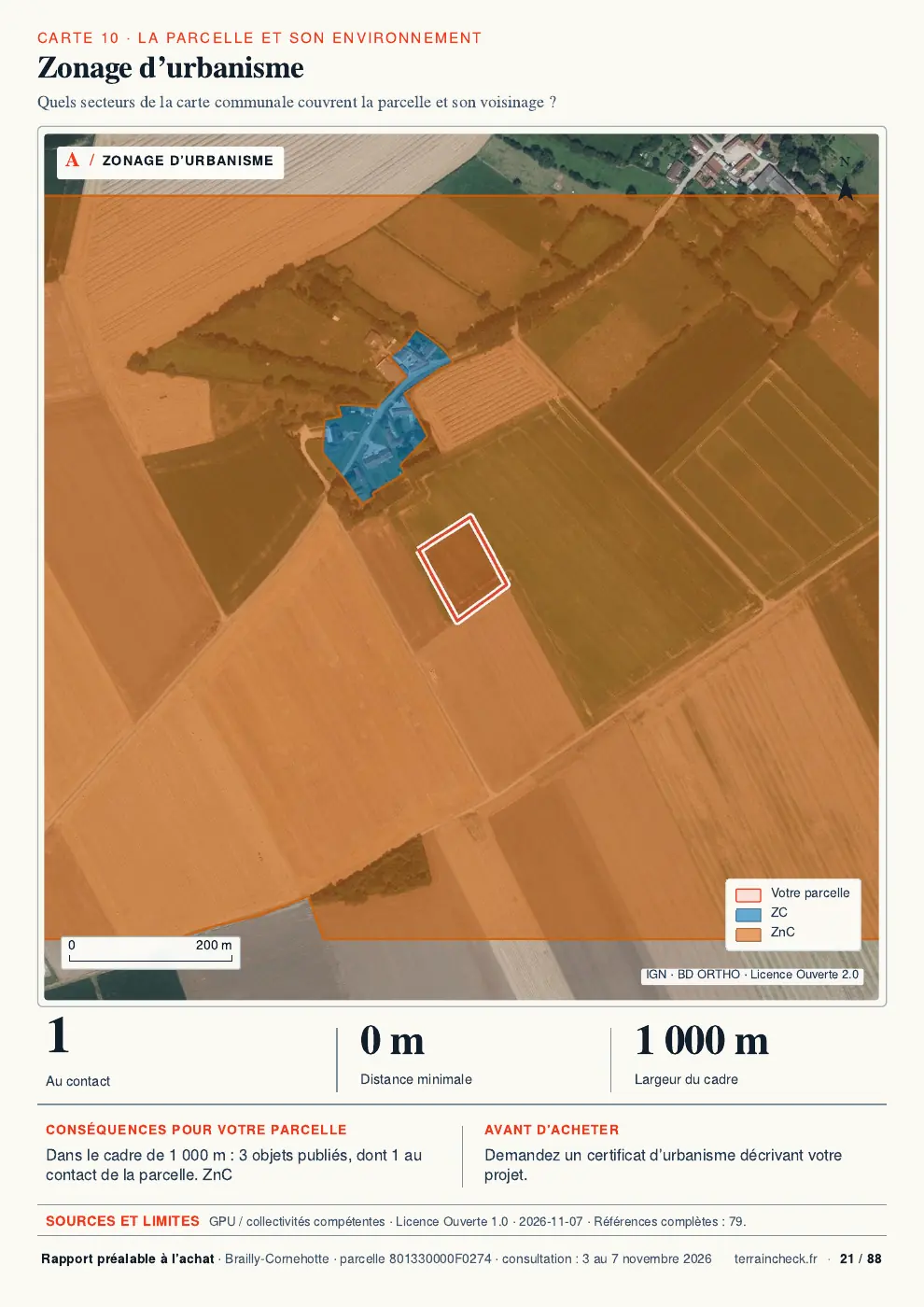
- The map uses four labels: ZC (open to building), ZCa (reserved for business use), ZnC (closed to building, with exceptions set by law) and RNU for any part of the commune the map does not cover.
- The map contains no rules on height, setbacks or appearance. Those come from the national planning rules (RNU), which can justify refusing a permit even in a ZC sector.
- Before you sign: an operational planning certificate (certificat d’urbanisme opérationnel), free from the mairie (town hall), which has two months from receipt to reply.
On this page
Buildable and non-buildable sectors, and no rulebook
A carte communale is the planning document of communes, or of the inter-municipal bodies in charge of planning, that have no PLU. It consists of an explanatory report and one or more maps, with the public-interest easements (servitudes d’utilité publique) attached.
Its main role is to mark out the sectors where building is allowed and those where it is not (article L161-4 of the Planning Code). It may also reserve a sector for business premises, notably those incompatible with nearby housing, and show sectors where a building destroyed by a disaster (sinistre) may not be rebuilt as it was.
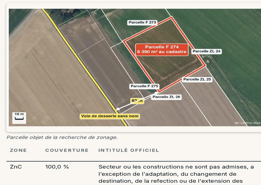
In a closed sector the law keeps some exceptions. Existing buildings may be adapted, repaired, extended or changed to another use, and outbuildings may go up close to an existing building. Buildings needed for public facilities, farming or forestry (including processing and selling farm produce where this extends production), natural resources or shared farm-machinery cooperatives (CUMA) are also possible, as long as they are compatible with farming, grazing or forestry on the land and do not harm natural areas or the landscape. Only the farming, forestry and CUMA projects also go to the département commission for natural, agricultural and forest land (CDPENAF) for an opinion. A house that fits none of these cases cannot be built in ZnC.
Height, setbacks, appearance: the national rules apply
Unlike a PLU, a carte communale cannot set detailed rules on how a building sits on the plot: density, setbacks, appearance, parking. The national planning rules (règlement national d’urbanisme, RNU, articles R111-1 onwards of the Planning Code) govern construction instead.
For a house, three rules matter. Unless it is built on the boundary, the building must stand back from the neighbouring plot by at least half the difference in altitude between the two points, with a minimum of 3 metres (R111-17), unless a reasoned exemption is granted (R111-19). A permit may be refused, or granted with conditions, if the project threatens public safety or health (R111-2) or harms the character of the area or the landscape (R111-27). And if water, sewerage or electricity have to be brought to the plot, the permit is granted only if the authority issuing it can say when, and by which public body or utility company, the work will be done (L111-11).
Permits are normally issued by the mayor on behalf of the commune; for a map approved before the ALUR Act of 24 March 2014, after a council decision or, failing one, since 1 January 2017 (L422-1).
| Question | Carte communale | PLU | Neither |
|---|---|---|---|
| Where can you build? | In the sectors the map opens to building | According to the PLU zones and rules | In the built-up parts of the commune (L111-3) |
| Outside those areas | Closed sector: exceptions in L161-4; part not covered (RNU): see below the table | Whatever the zone rules allow | Exceptions in L111-4, including a reasoned council decision |
| Height, setback, look | RNU | PLU rules; part of the RNU still applies (R111-1) | RNU |
| Who issues permits? | Normally the mayor, for the commune (L422-1 a) | Normally the mayor, for the commune (L422-1 a) | The prefect or the mayor acting for the State (L422-1 b) |
The three sets of exceptions never mix: L161-4 applies under a carte communale, L111-4 only where there is neither a PLU nor a carte communale (L111-1). Sources: French Ministry for Ecological Transition: the carte communale, a planning document for granting building permits; Planning Code, art. L161-4; Planning Code, art. L111-1; Planning Code, art. L111-3; Planning Code, art. L111-4; Planning Code, art. L422-1. Accessed 13 November 2026.
Sources: Planning Code, art. R111-1; Planning Code, art. R111-2; Planning Code, art. R111-17; Planning Code, art. R111-19; Planning Code, art. R111-27; Planning Code, art. L111-11; Planning Code, art. L422-1. Accessed 13 November 2026.
Where to see the map and how to read it
- Open the Géoportail de l’urbanisme, the national portal to which communes send their planning documents (in French only). Search for the address or parcel, then note the sector label and the date the map was approved. Cost: nothing. Time: a few minutes (TerrainCheck estimate). No parcel number yet? See how to search for a parcel.
- Go to the mairie, which must make the approved map available to the public. Ask for the explanatory report (rapport de présentation), which says why each sector was drawn, and for the list of attached easements. Ask whether a revision or a PLUi is under way. Cost and time: none set by the texts cited.
- Apply for an operational planning certificate at the mairie, describing the project (a house, roughly where). It is free. The town hall has two months from receipt to answer; if it does not, a tacit certificate freezes the rules but does not say whether the project can go ahead. More in our planning certificate guide.
For a plot cut by a sector line, see plot split between two zones. An area labelled RNU is, under the national standard, a part of the commune the map does not cover. It is not a ZnC sector, so the L161-4 exceptions are not the rule there. The national planning rules apply (L111-1), and a permit needs the binding opinion of the prefect, the State’s representative in the département (L422-5). Article L111-1 sets aside the limited-building rule of articles L111-3 and L111-4 “in areas where […] a carte communale applies”; for a plot outside the map’s boundary, ask the town hall to state in the operational certificate whether it lies in a built-up part (L111-3) or fits a case in L111-4.
Sources: Géoportail de l’urbanisme (national planning portal); Planning Code, art. L133-1; Planning Code, art. L133-2; Planning Code, art. L163-7; Service-Public: planning certificate (certificat d’urbanisme); Planning Code, art. R*410-10; Planning Code, art. R*410-12; Géoportail de l’urbanisme: CNIG carte communale data standard v2022-10 (labels ZC, ZCa, ZnC, RNU); Planning Code, art. L422-5; Planning Code, art. L111-1. Accessed 13 November 2026.
A map that can change: revision and PLUi
A carte communale is revised the same way it is drawn up: a public inquiry (or, by reasoned decision, online public consultation), approval by the municipal or inter-municipal council, then by the prefect, who has two months; after that the map counts as approved. Opening a closed sector to building requires showing that land already built up cannot meet the need (L161-3). See also land that may lose its building status.
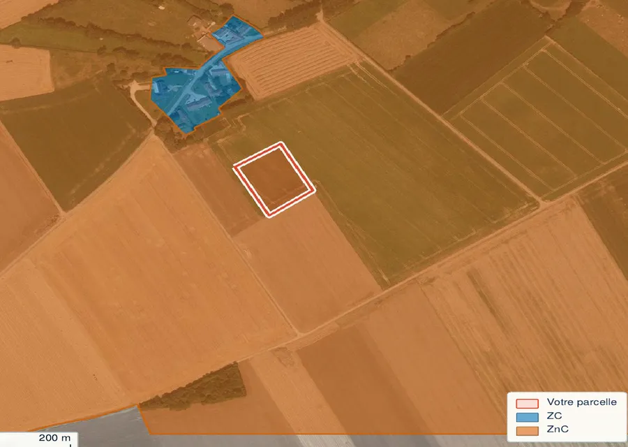
The usual change is a switch to an inter-municipal PLU. Adopting a PLU repeals the carte communale for the area it covers, from the day the council decision takes effect (R163-10). A plot in ZC may then end up in a farming or natural zone, or the reverse. The commune in our example, Brailly-Cornehotte (Somme), has a map approved on 25 February 2020 and a PLUi launched by its inter-municipal body on 12 July 2022.
While the new plan is in preparation, once the council has debated its strategic outline (the PADD), the authority may defer its decision on a permit that would compromise the future plan (L153-11). The deferral must state reasons and cannot exceed two years, or three in total on different grounds (L424-1). The planning certificate must say if a deferral could be applied (L410-1).
Sources: Planning Code, art. L163-5; Planning Code, art. L163-6; Planning Code, art. L163-7; Planning Code, art. L163-8; Planning Code, art. L161-3; Planning Code, art. R163-10; Planning Code, art. L153-11; Planning Code, art. L424-1; Planning Code, art. L410-1; data.gouv.fr: SuDocUH, planning documents by commune at 31 December 2024 (Ministry for Territorial Cohesion). Accessed 13 November 2026.
In the report: parcel F 274 in a ZnC sector
Before the compromis in a carte communale commune
- Sector label read on the Géoportail de l’urbanisme (ZC, ZCa, ZnC or RNU) and the date the map was approved.
- At the mairie: the approved map, the explanatory report, the attached easements.
- Asked: is a revision or a PLUi under way? Has the PADD debate taken place?
- In ZnC: does the project fit an L161-4 exception? If not, no new house.
- Operational planning certificate applied for, with the project described; answer within 2 months.
- Water, sewerage, electricity: who brings them and by when.
- Compromis subject to obtaining planning permission.
Next: reading a PLU before buying if the commune moves to a PLUi, and checking whether land is buildable.
Common questions
Can I extend an existing house in a ZnC sector?
Yes in principle: the carte communale allows existing buildings to be extended, adapted and repaired, and an outbuilding close to an existing building (L161-4). You still need the right planning consent, assessed under the national rules (RNU).
Are easements shown on the carte communale?
They are attached to it. One year after the map is approved, or after a new easement is created, only easements attached to the map or published on the Géoportail de l’urbanisme can be held against a planning application (L162-1). See where to find easements.
Who decides to revise the map?
The commune or the inter-municipal body in charge of planning. A revision follows the same steps as drawing it up: public inquiry or online consultation, council decision, then the prefect’s approval, deemed given after two months (L163-5 to L163-8).
Keep reading
Building in a French commune with no local plan: the national planning rules (RNU)
Plot split between two zones in France: what can you build where?
French planning certificates: information or operational CU before buying land
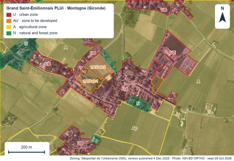
Reading the PLU before you buy: zone, rules, easements and pending changes
A plot under a carte communale? Start with its sector
Pick the parcel on the map. The report lays the published sectors of the carte communale over the aerial photograph, then covers natural hazards, clay soils and recent sales nearby, each with its source and date and explained in English. It does not replace a planning certificate. Free check, PDF report for €29 (€39 in French and English).
